As noted in the previous post, there have been at least 460 human
cases of H7N9 reported in the current H7N9 outbreak between November 1, 2016
and February 27, 2017. Of great concern is a possibility that many of these
cases are a result of human-to-human transmission. There is little publicly available
information about the relationships, if any, among these hundreds of cases. To
date, only four two-person clusters have been reported by the World Health Organization
(WHO, January 17 and February 20) with family members comprising three of the
clusters. For all four of these clusters, the WHO notes that human-to-human
transmission cannot be ruled out.
One important clue to the nature of the outbreak is the geographic
distribution of the reported cases. An indirect signal of human-to-human
transmission can be multiple cases occurring in a localized geographic area within
a short period of time. The recent WHO line listing of H7N9 cases from China (Influenza at the Human Animal Interface: Summary
and Assessment, February 14, 2017), only provides the province or region for
each of the reported cases. Line lists of cases provided by the Centre for Health
Protection (CHP) Weekly Influenza Report
provide additional geographic locational information to the prefecture level (administrative
level 2) for individual cases. The Food and Agricultural Organization of the
United Nations (FAO) line list of H7N9 cases occasionally provides the
geographic locale of the county or administrative level 3 for some individual
cases.
The most accurate locational information for individual
cases is reported in local public health reports on Chinese websites. This information
has been translated to English by members at FluTrackers. Sharon Sanders at
FluTrackers has linked to these translated reports in the FluTrackers running
list of H7N9 cases. Unfortunately, local publication of data of confirmed H7N9 cases
in China are infrequent, so geographic details about individual cases beyond administrative
level 2, the prefecture level, are limited to only a handful of the reported
cases in this outbreak.
However, even with limited geo-locational information for
individual H7N9 cases, the geographic distribution of cases can be plotted and
is very informative. The map below provides a heat map of the distribution of
cases in eastern China computed from the prefecture level data. Overlaid on
this map are plotted locations of individual cases. The map shows the concentrations
of cases in the 2016-2017 H7N9 outbreak in the provinces of Jiangsu, Zhejiang,
Anhui, and Guangdong. In southern Jiangsu, hot spots include Suzhou, Wuxi,
Taizhou, and Changzhou. In northern and eastern Zhejiang, the hot spots are Hangzhou,
Ningbo, and Wenzhou. Hefei is the hot spot in central Anhui province and in central
Guangdong, Guangzhou is the location with the most reported infections.
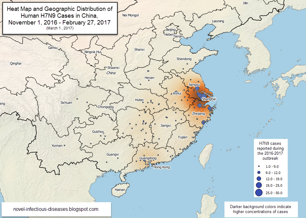
This map also shows that cases are widely scattered
throughout many provinces during the current outbreak. The widely dispersed nature
of these cases provides indirect support that human-to-human transmission is not
occurring in these areas and the infections are resulting primarily from
animal-to-human transmission. Even the increased number of cases in the hot
spot locations does not mean that human-to-human transmission is occurring. The
prefecture level cities mentioned above have very large populations most
exceeding several million people. Were human-to-human transmission occurring in
these areas we would expect many more reported cases.
No comments:
Post a Comment
Note: Only a member of this blog may post a comment.